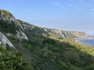
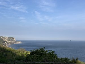
Living in a town with a significant landmark has always been very appealing. Folkestone, a town in the south east of the UK has the white cliffs surrounding it. This famous feature is a treasure to the town.
An aftermath of the Brexit turmoil leads us to think of the close connection my town, Folkestone, has to France, it being only 32km away.
Being in a country that has a completely different currency and time zone to Europe has always puzzled my mind. As in fact Folkestone is situated closer to France than it is to London. It takes just half an hour with the Euro Tunnel train to from Folkestone to Calais. Just under an hour to London.
Furthermore, with the result of Brexit, in the years to come we are expecting more separation from our old land connecter. We have been on the receptive end for the incoming of refugees and immigrants. It has unfortunately caused a very negative stereotype against them.
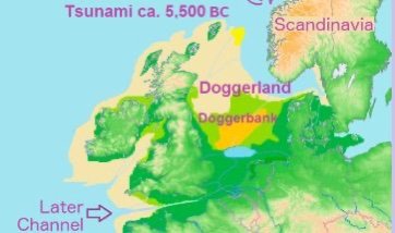
Doggerland
Previously, at the end of the last ice age, only 10,000 years ago, Doggerland, as it is known as nowadays, was an area of low lying land that connected what is now the British Isles with the rest of Europe.
Subsequently, In terms of geological age, this period of less than 10,000 years ago is incredibly recent. In fact, the geological age in which we are now living is called the Holocene which is a term derived from Greek meaning “wholly recent”.
As a result, what is now called the British Isles, was part of the area of land that made up the north west corner of the continent of Europe, I.E. a contiguous land mass. Where the North Sea is now, was an area of gently sloping hills, marshland, heavily wooded valleys and swampy lagoons.
It was populated by Mesolithic peoples who were hunter gatherers who migrated with the seasons, fishing, hunting and gathering food such as hazelnuts and berries.
What happened?
It is generally reckoned that about 8,200 years ago, a catastrophic release of water from a North American glacial lake occurred. At about the same time, a tsunami from a submarine landslide off Norway inundated this area of low-lying land. It was a period of climate change rather similar to our own time. Evidence shows Doggerland was slowly disappearing, therefore it may not have occurred over night, but over a period of time.
In fact, the inhabitants then were forced to move to what is now the British Isles to the west and the Netherlands to the east. We now give this former area of land the name Doggerland. This is after the name of the central fishing area called Dogger Bank which is so called because the Dutch fishing vessels which fished this area were called “doggers”.
However, evidence of Doggerlanders’ nomadic presence can be found embedded in the sea floor where modern fisherman often finds ancient bones and tools that date to about 9,000 years ago.
Using sophisticated seismic survey data acquired mainly by oil companies drilling in the North Sea, the scientists have been able to reconstruct a digital model of nearly 46,620 square kilometres [18,000 square miles] of what Doggerland looked like before it was flooded.
Read here for more information
https://www.nationalgeographic.org/maps/doggerland/